Our Services

by admin

As one of the most advanced spatial information data providers in Nigeria, STL specializes in placing socio-economic and developmental information in a spatial context. The Company’s sophisticated hardware and software enable it to undertake most types of GIS and mapping consultancy including database development.

We also assist some of our clients to visualize object relationships in their database by integrating spatial context into their database. This way, our clients are empowered to make informed business and technical decisions based on the power of visual interpretation of the contents of their databases. This feat would have been impossible to understand using the traditional row-column formats.

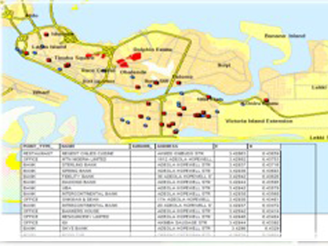
STL specializes in assisting our clients to visualize objects spatial relationships in their databases. This way, our clients are empowered to make informed business and technical decisions based on the power of visual interpretation of the content of their databases. This feat would have been impossible to understand using the traditional row-column formats.

Data Development and Automation
  • Digital GIS data from hardcopy maps and drawings
  • Geocoding and address matching
  • Data conversion, CAD to GIS transformation

Data Integration

  • GIS Integration and Solution
  • Rubbersheeting and layer adjustment
  • Geospatial database and data schema design
  • Loading/integrating spatial data into Oracle, SQLServer, MS Access

 Data Quality Assurance and Quality Control

  • Automated data quality assurance routines and checkplotting
  • Independent QA/QC for photogrammetry projects

Since its founding, STL has been dedicated to creating high quality cartographic products in hardcopy or digital format.  Care in map layout, color, symbology, and overall design, are hallmarks of all our work.   We have both A0 size scanner and A0 digitizing tablet that can be used to convert your hard copy maps or drawings into digital formats. We take your data through the full length of digitizing cycle including topology creation, and cleaning.

Spatial analysis requires comprehensive information, knowledge and the use of appropriate methods.  STL effectively brings these three factors to bear in undertaking spatial analysis, whether in the public or private sector. STL’s team of GIS professionals is highly experienced in undertaking spatial analysis projects, including spatial modeling. GIS technology provides a powerful way to see things in context and investigate spatial relationships among different data sets.  It is vital that the data used in a GIS analysis be of sufficient quality, detail, currency, and completeness to support the needed conclusions.  STL’s GIS analysts and programmers are prepared to help you meet your analytical requirements with confidence. 

  • Many functions and tools are already built into off-the-shelf GIS software; STL’s analysts can efficiently perform the analysis for you and/or teach you how to do it for yourself.
  • For complex analysis, STL can help you to construct models that will automate the data processing and analysis as a series of steps and operations.
  • In some cases, new tools or applications are required. STL can build easy-to-use tools that encode complex analysis and operations, and that facilitate the exchange of data and results between GIS and other software for increased productivity and function

At STL, we believe in the power of GIS and it shows in our work, ethic, our solutions and our commitment to client’s success. We are offering forward looking companies in Nigeria about 7years expertise at helping them to make informed technical and business decisions in their endeavors. Our geospatial solutions are usually tailored to fit their specific requirements in order to leverage corporate knowledge and increase efficiency and effectiveness in your operations.

STL’s Professional services

Each of the analyses above can be provided as either a consultancy service or can be performed in-house using MapInfo Professional software –a professional mapping and business making tool based on the visual power of GIS and map.

GIS Consultancy Services

For those companies that would prefer to out-source either a single GIS project or a long-term strategic venture, STL can help. STL can either carry out project-based consultancy assignments or second staff to a clients' premises to work on-sites. Projects are typically bespoke and tailored to each client's commercial requirements.

In-House Empowerment GIS

STL empowers its customers to perform their own market analyses and modelling if they have the in-house resource and skill to do so. A professional off-the-shelve GIS and mapping software is provided on license as a desktop application. Unlimited training and a team of dedicated technical helpline is also provided.