Market Research

by admin

Location-based Solutions for Sales & Marketing

The future of your organization depends on the decisions you make today. The key to smart decisions is putting accurate, relevant business to business market research and business data into the right business context. The application of GIS in Nigerian businesses has grown rapidly in the recent years.

In today’s fiercely competitive environment, retailers and distributors of consumer goods must use every advantage to acquire and retain customers, plan market expansion and contraction, locate profitable sites, stay abreast of changing consumer tastes, and act faster than the competition. Geography fundamentally influences and connects culture, business, society, and lifestyle. Geography answers many business and marketing queries. Over 70% of all decisions made in retail marketing and distribution has to do with geography.

Consider the following self-evident, axiomatic statements:

  •  Customers buy from shops that are near their homes.
  •  Shops serve a certain area around their location.
  •  Distribution is cost effective when trucks follow logical routes.

The operative words in these statements are ‘near’, ‘area’, and ‘routes’. Each of these words has a spatial meaning, that is, they refer to a geographical relationship.  It is only normal then that the business software that is used to manage sales and distribution should be able to deal with the concept of geography.

At STL, we do not just talk theoretically about how GIS can assist in Sales and Marketing in Nigeria, we have actually implemented several projects successfully for some big companies in Nigeria.

Some of product distribution companies in Nigeria have created a distribution network of dealers across Nigeria ranked into Major, Minor and sub dealers. Over the years, they have discovered managing their network using tabular databases in Excel, Microsoft Access is very ineffective. They found it impossible to visualize the logical relationships between the dealers using these traditional methods.

STL can help to define and map out sales territories for major, minor and sub dealers in a retail distribution network. Using the power of GIS and digital maps, STL can  identify territory overlaps or gaps in the marketplace in a consistence and efficient manner. This type of analysis can help retailers develop the optimum territory definition to achieve the best market coverage and assist in helping it to assess the sales potential of each territory for targeting setting.

How will it help my business?

  • Flexible analysis of multiple datasets and improving decision making

  • Putting a potential site into visual context

  • Understanding the impact of competitors’ stores in the area

  • Identifying profitable new store locations to maximise return on investment

  • Setting accurate revenue and profit targets

  • Accurately understand the potential revenue and profit and market share achievable

Case Study

Click here to see how STL used GIS to assist UBA PLC -Nigeria’s largest bank in branch coverage Network Optimization analyses as part of a N9.2billion expansion project

For any city within Nigeria that a retailer operates in, for which it has sales data available, STL can help in understanding and benchmarking its best performing outlets and more importantly explain why they are performing so well using the visual power of GIS.

How will it help my business?

By benchmarking each of your dealers within the distribution chain against those that are performing the best STL can help you identify the critical success factors that can be focused on to improve the performance of your worst performing dealers.

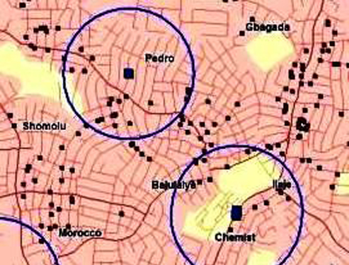
STL can help retailers evaluate site attractiveness and the strength of local competition.

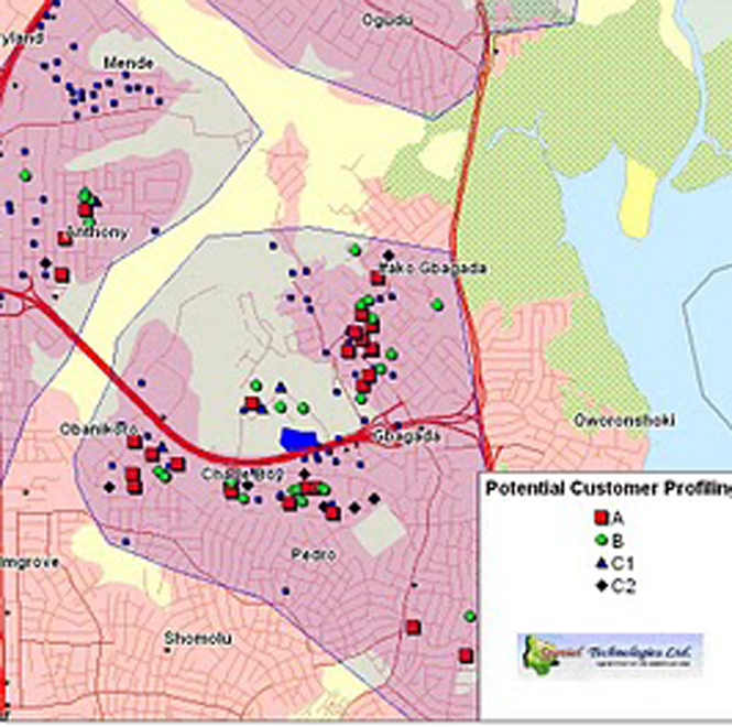
GIS & Competitive Analysis

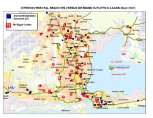
Understanding how competing brands position themselves can allow retailers to learn from their mistakes and successes, and act in a distinctive and powerful way. More importantly by understand where the competitors are located can provide a powerful tool to stay ahead of the competition. STL can map the location of any of our clients’ competitors to assist them to position themselves better.

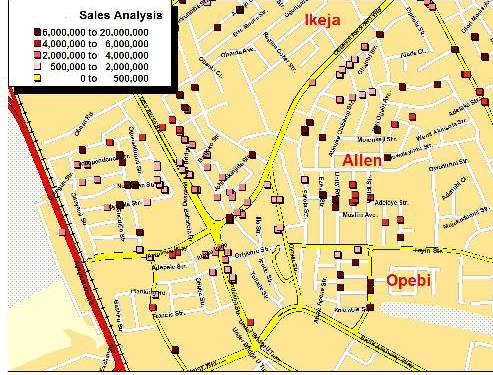
To calculate market penetration, you need to quantify the amount you have and compare it with the amount you could have had.

The number you have may come from a sample store exit survey, from loyalty card data, from the deliveries or order processing system.

The potential market for a consumer product will be related to the population. You could estimate that all households are potential users of your service or perhaps you know that only elderly, economically active or people of a specific social class are likely to be interested.

Case Study

Click here for a case study on how

GWC of France depended on STL’s solution to calculate market penetration of broadband market in Nigeria

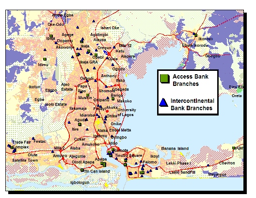
Strategic Business Planning using GIS

When you are looking at programmes of product network distribution expansion, refurbishment, rationalization of consolidation in a highly competitive market like Nigeria, it is important that you get your location decisions right. Using powerful mapping modelling technology STL can help retailers  model different network scenarios and understand the financial impacts of any decision.


STL’s Professional services

Each of the analyses above can be provided as either a consultancy service or can be performed in-house using MapInfo Professional software –a professional mapping and business making tool based on the visual power of GIS and map.

GIS Consultancy Services

For those companies that would prefer to out-source either a single GIS project or a long-term strategic venture, STL can help. STL can either carry out project-based consultancy assignments or second staff to a clients' premises to work on-sites. Projects are typically bespoke and tailored to each client's commercial requirements.

In-House Empowerment GIS

STL empowers its customers to perform their own market analyses and modelling if they have the in-house resource and skill to do so. A professional off-the-shelve GIS and mapping software is provided on license as a desktop application. Unlimited training and a team of dedicated technical helpline is also provided.